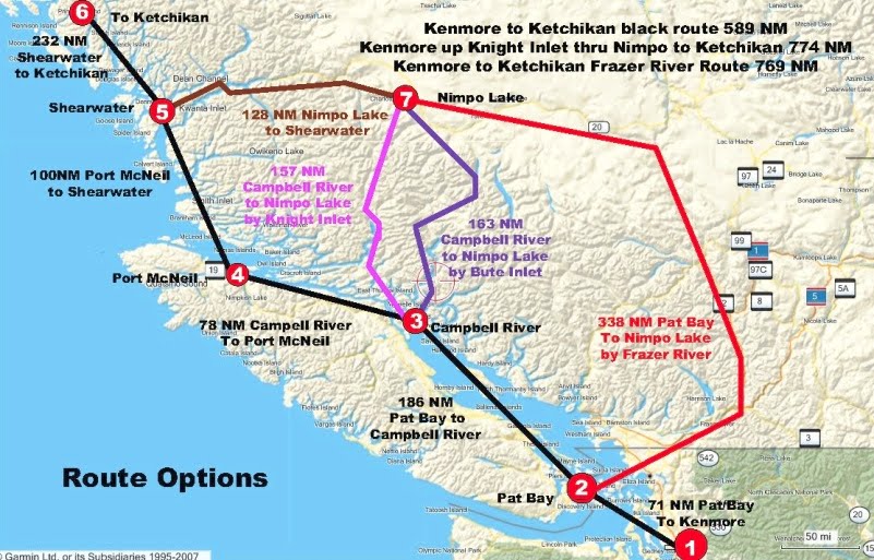
Going up the coast from Seattle to Alaska is a challenging flight when the weather starts to deteriorate. In the summer months this is going to happen some place along the route at least 50 percent of the time. I have made 20 trips up and down the coast and another 10 to the Canadian coast. On the flights from Seattle to Ketchikan I make it in one day 75% of the time. On CAVU day (no clouds) I leave Kenmore and go through customs at Pat Bay (Victoria International), then to refuel at port McNeil and then nonstop to Ketchikan. The below chart shows the big picture strategy for planes on straight floats.

Decision options Kenmore to Ketchikan:
Decisions at 1: I file in the US for my trip to Pat Bay to go through customs. Pat Bay allows me to make my route decision without a mileage penalty. I have already filed with Kamloops (See cheat sheet for phone numbers) and have a route picked. I always try to fly the shortest route. (The Black line) any of the inland routes through Nimpo Bay are going to add about 190 NM to your trip.
Decisions at 2: At Pat Bay I make a decision by calling Kamloops whether I am going to fly the black line route or the red line route to Nimpo Lake. Keep in mind the weather usually gets better in the afternoon. I only go the Nimpo route if I have a report which gives me no chance of making it to Campbell River. If I get stuck I have a good place to stay at Campbell river for me and the plane. See Commercial Float Plane Stops
Decisions at 3: At Campbell river I get reports for Port Hardy, Egg Island, Pine Island, Addenbrooke Island and Bella Bella. These points are between Port McNeil and Shearwater. If any of them are below 1000 feet I take a look at the Bute and Knight Inlet. Kamloops has satellite information but little else. A lot of the times the cloud bank comes down the Johnson straight and stops at around Campbell River. When this happens head for Nimpo Lake by Bute or Knight Inlet. Bute is the first one you see and If it is clear it is the one I pick. If I have great visibility and can see Knight looks open then I proceed up Knight inlet. Remember is you take this route you are added about 200 miles to the trip but you can stop at a great place for fuel in Nimpo Lake and spend the night. See Commercial Float Plane Stops If it is clear up to Port McNeil you can also stay there for the night. And get fuel.
Decisions at 4: At Port McNeil you get the weather report to Shearwater including Pine, Egg and Addenbrooke. If the Weather is over a 1000 I proceed. Besides Shear Water there are two other places to spend the night if you cannot make it all the way. Duncanby which is a fishing Lodge who may or may not be able to accommodate you and Dawson”s Landing. Shear Water is set up for planes stopping and have ”good” rooms, food and 100LL.
Decisions at 5: Over Shear Water I call Kamloops to get the weather up Prince Rupert. And proceed if I get a good report. If not I stay at Shear Water for the night. Take a look at Commercial Float Plane Stops to see where the dock is. You cannot see it after you have landed. Leaving you are going to fly to the Grenville Channel. The route in my route load shows a direct route but if you look at my waypoints there is an outside and an inside option. Low conditions could force you to take one of them.
Decisions at 6: At Prince Rupert call Kamloops and get the weather to Ketchikan. If you have bad weather or need fuel go to Seal Cove. There is no 100LL at the airport.
Decisions at 7: Your only weather information at Nimpo is to call Kamloops. If the weather is bad at Nimpo or Shear Water spend another day at Wilderness Rim Lodge and go fishing. See information at Commercial Float Plane Stops

The above waypoints and routes show the main options for dealing with bad weather which normally starts at Port Hardy all the way to Prince Rupert with the worst being from Port Hardy to Sheer Water. Neil Sherod taught me these routes, Neal has 6000 hour of float time with most of it being between Seattle and Rivers Inlet delivering fisherman to the resorts in the area. When you get into the Johnson Straights and have bypassed the Bute and Knight inlet options you are now going to fly direct or one of the inland options which will take you to Rivers Inlet. The two main ones are the blue circles known as the back way into Rivers Inlet and the Hi Way shown with the blue flags. When you are going down the straights and you see a huge fog bank in front of you but you can see the mountain tops on the Rivers Inlet route it is time to turn right over the mountain. The Hi Way is used when conditions are low. The Hi Way does not have any hi points you have to go over and is over inland water most of the way giving you landing options in smooth water. I have flown these routes for 15 years and they require a good understanding of the area. Load up my way points and try them on a clear day.
Also become familiar with the excellent resources from Nav Canada at Weather Websites
Load the Garmin by going to downloads and then Garmin. To work with this data you need MapSource which is available on the Garmin website. You can go to downloads and then Google Earth Files to get Waypoints and Routes in a Google earth format. Open them with Google Earth to get a good look at the terrain.


